History of St. Dominick Pre-history – 1485 Map 1: Part 3 Iron-Age

Now that DOMINICA is finished I hope to continue the occasional series I had previously begun here and elsewhere.
While you’re here PLEASE SIGN UP to this blog if you’d like to hear more – the box is at the top of the post on the right – Let’s keep in touch! I do not post often, perhaps fortnightly, so posts are easy to miss.
{I had been building my followers since 2011 – and had around 640 when an unfortunate technical issue meant that I lost ALL of these followers contacts – and need to start again
– so please do join to keep in touch}

To find the Introduction and PART 1 and PART 2 CLICK HERE then just scroll down to the first post – and then read your way up through the eras.

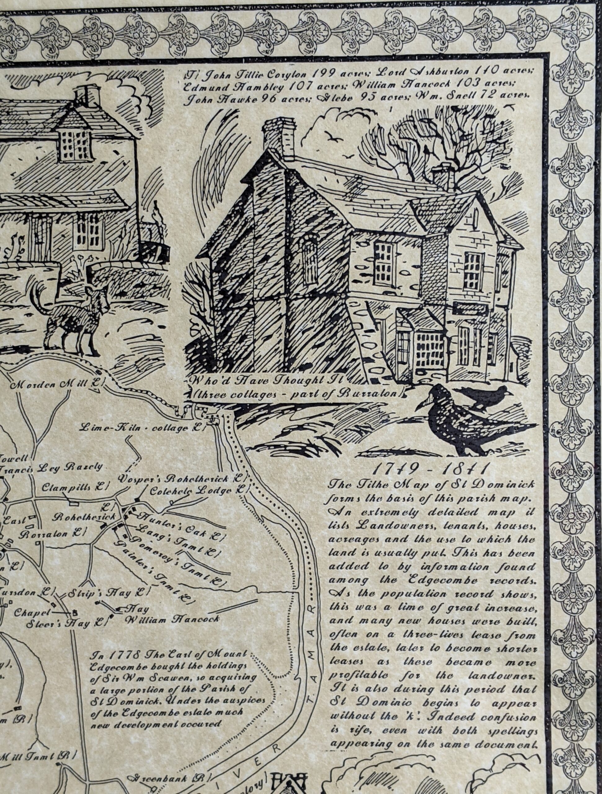
The Iron Age (800 BC – AD 43) left more marks than the Bronze Age upon the landscape of the St. Dominick parish area. The most notable of these being at Berry Farm. See section of map below:
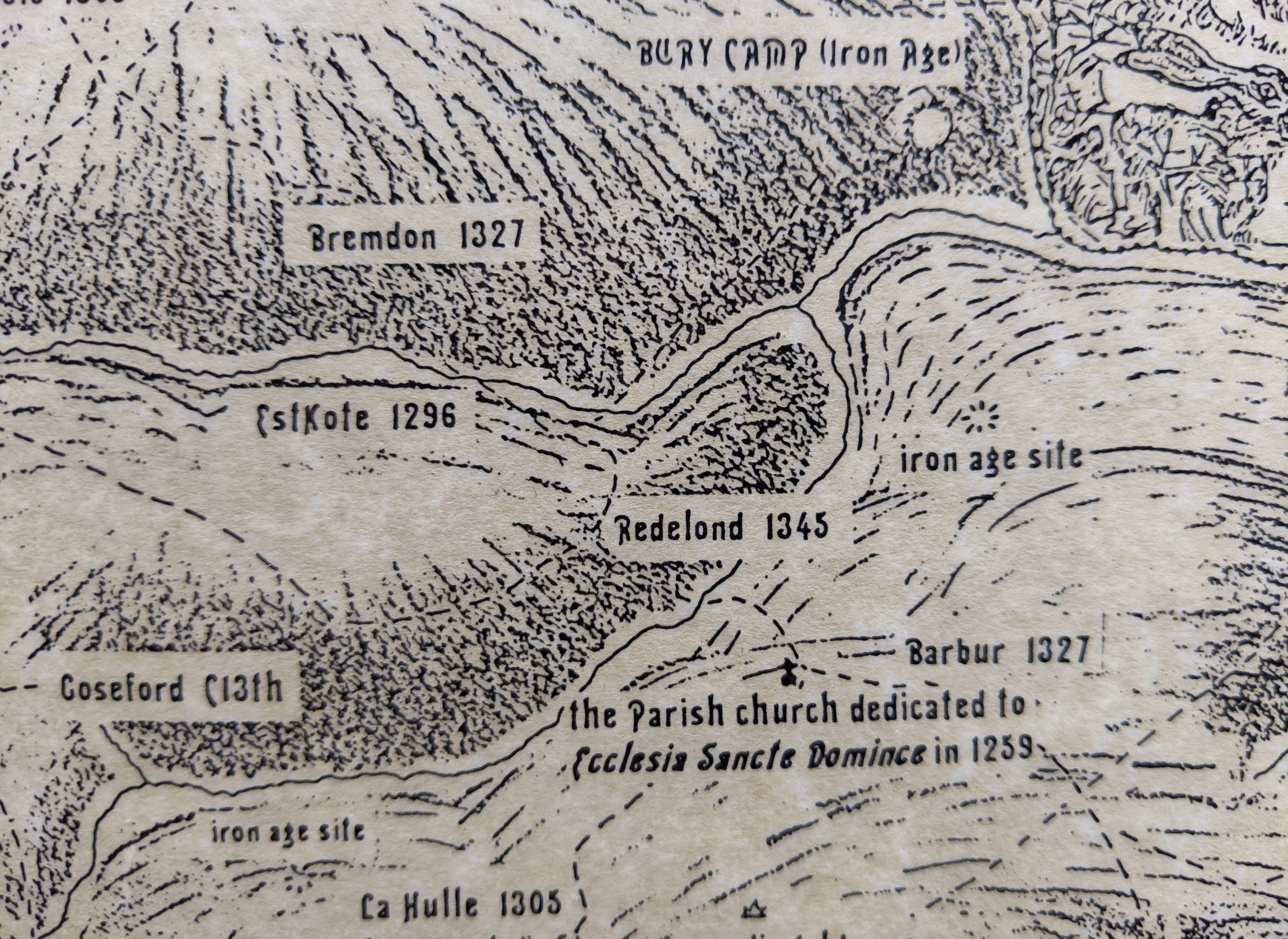

The change of name from ‘Bury Farm’ (with unrelated connotations as to its meaning) to ‘Berry’ could be relatively recent – though it was written as Berry on the Tithe map (1841) it was still written as ‘Bury’ on the 1892 – 1914 OS map.
Use the Reference (1) at the end of this post, to link into a side-by-side view showing the 1892 – 1914 Ordnance Survey map
A ‘Bury’ is the name given to a ditch and bank ‘fortification’ created during the Iron Age – and are sometime referred to as ‘rounds’ or ‘camps’ when of this smaller nature.

The listing for the ‘Round at Berry Farm’ (Reference: (2), St. Dominick from Historic England reads:

“The monument includes a round, situated on the east-facing summit of a spur, overlooking the steep valley of a tributary to the River Tamar. The round survives as a roughly-circular enclosure defined by a rampart and largely buried outer ditch with a similarly defined annexe to the north west. The main enclosure measures approximately 65m in diameter internally. The rampart survives differentially, but reaches a width of up to 10m and an external height of 0.8m up to 2m to the north and west. To the south it has been incorporated into an existing field boundary. The annexe rampart has been partially fossilised within existing field banks, although to the north the rampart stands to a height of 1.7m above the accompanying ditch which is some 7m wide and 0.3m deep. Elsewhere it has been cut by farm buildings or is preserved as buried features” (1) (noted as a legacy record – first listed 1957)

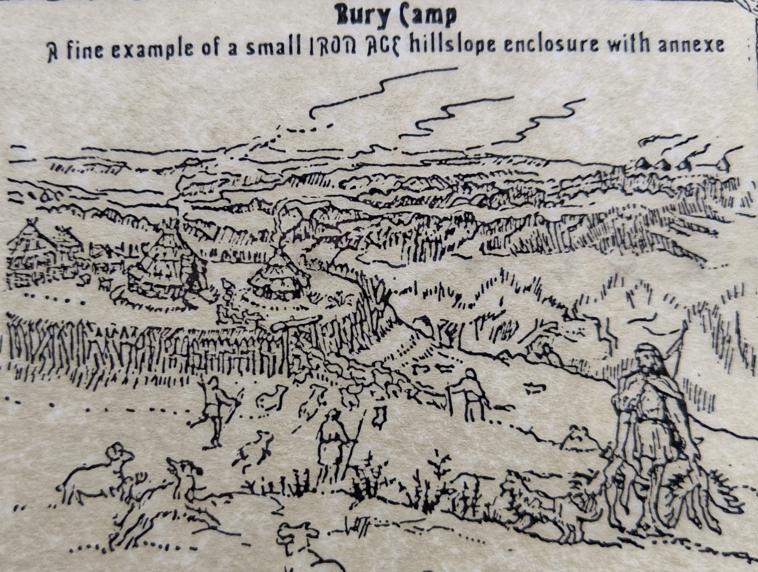
The difference between the designation of a ‘Round’ and a ‘Hillfort’ is one of magnitude firstly. Locally we can easily see the difference between Cadsonbury just outside Callington (a Hillfort, on the top of a steep-sided hill, defended by a deep ditch (still 1.3m) and a high bank (still 2m internally) and the ‘Round at Berry Farm’ which is on the slope of a hill, at a point that makes a promontory over the stream valley, with steep sides only on the stream side. It too has a ditch and bank but was probably never as substantial as that of Cadsonbury, and encloses a much smaller area though with annexe attached (a squarish enclosure) which, it is thought, animals could be herded into if under attack. There is also a ‘captured-spring’ well house (much degraded) beside the lane that passes the Round at Berry, on the higher side, and only about a 100m away from it.

There wasn’t much room for a large collection of houses within the space of a Round like at Berry, and it is possible that it was mainly the homestead of the local leader, a sort of clan chief, and his retinue, but also a refuge should the people under their protection be under attack. The people, mainly farmers would therefore live outside this enclosure on their own land, but paying tribute to the chief (who, in that culture, could be male or female) and both seeking refuge with them and fighting with them should their area be under attack from other clans.

See below – an artist’s impression by ©Mary Martin
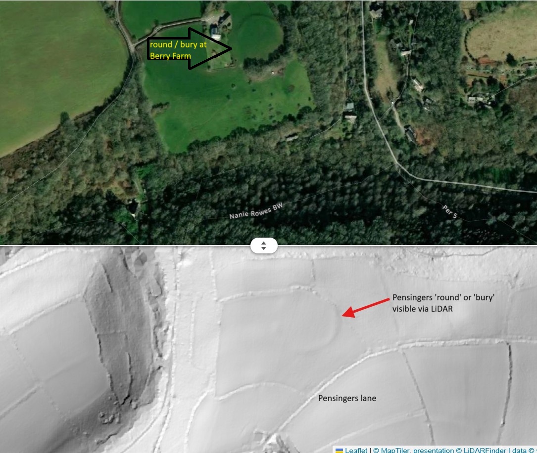
In 1994, whilst we were researching the History of St. Dominick for the parish map project – the Cornwall Archaeology department happened to send a team to do a ‘walking survey’ of St. Dominick, and we were fortunate that they reported before we completed and sent us a copy. From this we were able to put in some of the other details they believed should be there – though now almost lost through agricultural process. This suggested that there was another iron-age bury at one time, across the stream from the Round at Berry. This would have been on the promontory, with a steep drop to the stream-side, below Pensingers Lane. The field shapes in that area, even now, show as curved and it isn’t too hard to imagine an enclosure here.

More recently LiDAR {Light Detection and Ranging} surveys have shown this to be the case – with the outline of this second bury showing on the village side of the valley. See the LiDAR finder picture below.
Harder to imagine is the iron age enclosure the Archaeological walking team suggested they saw in topographical evidence for down below Trehill farm, overlooking the same stream, but when still very small so with not such steep sides. The area suggested does show as having its own spring source, however, a good sign for a settlement of sorts.

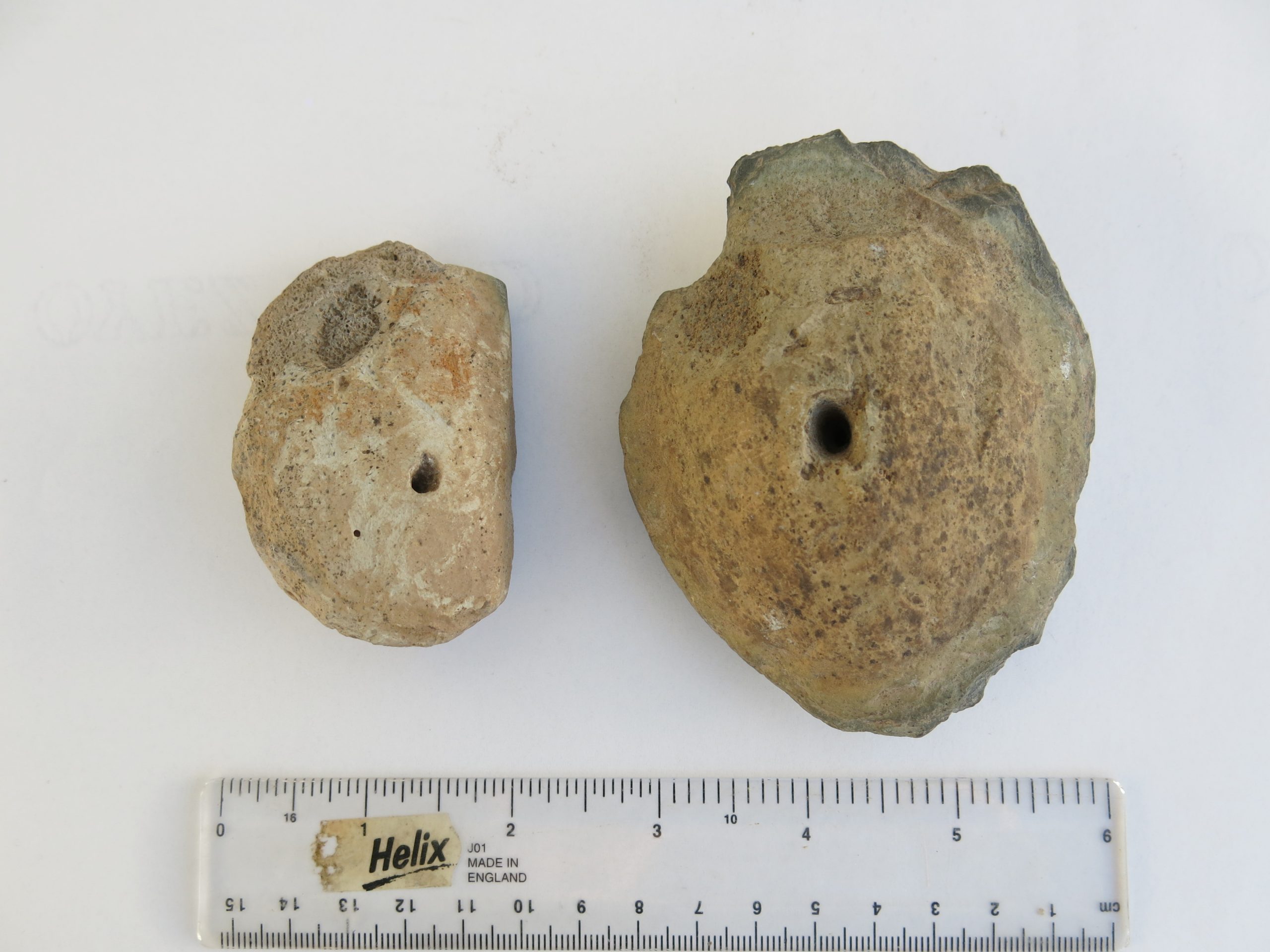
A couple of items*, dug up from over a foot down when post-holes were being made for a fruit-cage just above Radland Farm, may also come from this era. Made of slate and with, what appears to be, baked clay either side, they look like loom weights and show wear from where warp thread would have been attached. The warp thread would be hanging from a frame and weighted with something like these and the weft woven into it. *[neither age not use has been confirmed at this point]
References:
(2)Listing for Round at Berry farm, St. Dominick

https://historicengland.org.uk/listing/the-list/list-entry/1004393

(1) Side by side map 1892 – 1914 and satellite view

https://maps.nls.uk/geo/explore/side-by-side/#zoom=17&lat=50.49602&lon=-4.25504&layers=168&right=BingHyb

Don’t forget to sign up – Let’s Keep in Touch!

Remember – reviews of books are a great way to say ‘thank you’ to an author if you like what they write,
  Thank You

Questions or Comments on this post welcome!! Xx Ann

ps If you are reading this on email and would like to comment just click onto the title and it will take you to the actual blog – so you can comment there.

If it is the first time you have written a comment don’t worry if it doesn’t appear immediately, your first comment has to be verified (to keep the spam-bots out) and I do this personally – so I am sure to see your comment – thanks for reading – Ann

History of St. Dominick – Map 1 {Pre-history – 1485} Part 2 – Bronze-Age times

{For previous posts on the history of this area see St. Dominick History tab under ‘History – local and everyday’ Topic}
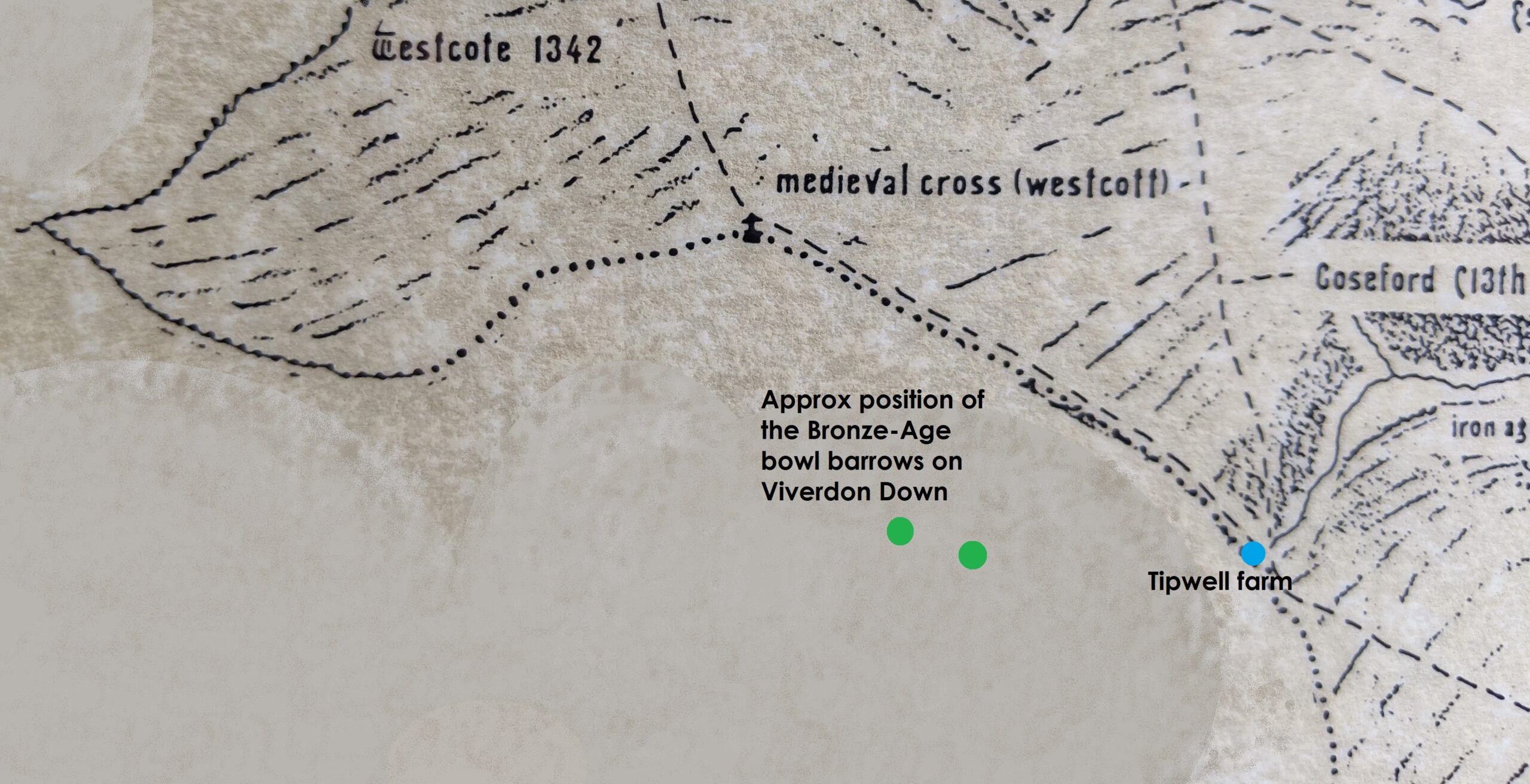
Staying with our ‘pulled out’ focus we can see the only really local evidence of occupation in the Bronze Age (2500 – 800 BC). Up on Viverdon Down are a number of Bronze-Age bowl-barrows (burial mounds) Note: Barrow-burial is on a continuum from late Neolithic and through the Bronze-Age, and it has been noted in ref (3) that these would have also been visible from Balstone down. See map below

Cornwall Council Strategic Historic Environment Service in their article on Bronze-Age monuments in Cornwall states “Some mounds are probably burials of important people. The largest barrows are in prominent locations on hilltops and ridges. The smaller barrows, which do not normally survive in lowland Cornwall, are inconspicuously sited amongst the fields and near the contemporary settlements.” and “We can conclude that the many barrows found elsewhere in lowland Cornwall (eg. Cubert Common, Veryan Beacon) would have had round house settlements close by which are not now visible.” (1)

St. Dominick counts as ‘lowland Cornwall’. The earlier Bronze-age settlements were up on what we now term moorland – Roughtor, for instance, had a very large settlement, Bodmin Moor had many and their field systems can still be traced by low stone banks. The thought being that, as the soil in these areas became degraded by over use, they had to move onto the lower land, setting the pattern for farming today. Most lowland settlements, therefore, would have been created in the Middle Bronze Age (circa 1500-1200 BC) and were collections of circular houses.

However, their monuments (the burial mounds) were still usually situated on high-ground where possible, as Viverdon Down is.

Historic England records this listing: “Two bowl barrows on Viverdon Down, 540m north west of Tipwell Farm – This monument, which falls into two areas, includes two bowl barrows situated on the summit of a prominent hill called Viverdon Down which forms the watershed between tributaries to the Rivers Lynher and Tamar. The barrows survive as circular mounds surrounded by buried quarry ditches from which the construction material was derived. The eastern barrow mound measures 18m in diameter and up to 1.2m high, the western barrow mound is up to 14m in diameter and 0.9m high.” (2) (This is noted as a ‘legacy listing’)

sketch of the cross-section of a typical bowl-barrow

Though these barrows have not been investigated by excavation the construction of them has been observed by the Cornwall archaeology Society in 1994 when they visited. “Two barrows remain as prominent surface features, but erosion is being accelerated due to continued ploughing. The latter has nevertheless revealed the structure of the barrow mounds, with turf stacks capped with (now leached) orange clay presumably dug from encircling ditches.
This degraded capping forms a near-continuous ring around the larger, more northerly, barrow. Both within this ring and outside it, dark organic weathered blocks of turf indicate something of the former extent of the stack. Between the barrows, and slightly westwards, a further area of darker material in the plough-soil suggests the former existence of a third, smaller, barrow.” (3)

Follow the link under (4) in the References to help you try to locate these on the satellite view of the area with ‘side-by-side’ maps.

The question is, where is the settlement that sited these bowl-barrows on the hill? Now, what follows here is supposition – but the landscape around the hill is, even today, sparsely populated by any ‘homesteads’ – but just off the crown of the hill (and at the edge of St. Dominick parish) is ‘Tipwell’.

The name gives us the clue – most likely a settlement or homestead based on a well* – and it is indeed where another significant stream for St. Dominick starts. As we noted in the last part of this series – a water-source is an essential for a settlement.
*[The name Towell – further into the parish – for instance, comes from the name At-Well (or AtteWell as it was written in the Manorial records) – so maybe that this is the origin of the name Tipwell too?]

A settlement at Tipwell would also have had the advantage of being near to the route of the ridgeway – which would still have been in use at this time – and, if the hypothesis of the route also going down to the river is correct, it would be on that too – a well placed settlement.

However – as the Cornwall Council Strategic Historic Environment Service comments “the evidence of these lowland settlements have, largely, been completely ploughed away”(4) or, indeed, maybe the settlements themselves were just built over – so we may never be absolutely sure.

That is it for the Bronze-Age in our area – as nothing else has been found and recorded – unless you know different, if so, please let me know!

Did you know there were Bronze-Age barrows on Viverdon Down?

Do you have any comments on this History of St. Dominick so far?

We would love to hear from you 🙂

-Ann

References:

(1) & (4) Cornwall Council Strategic Historic Environment Service

https://www.cornwall.gov.uk/environment-and-planning/strategic-historic-environment-service/cornwall-and-scilly-historic-environment-record/access-to-monuments/find-by-period/bronze-age-2500-to-800-bc/

(2) https://historicengland.org.uk/listing/the-list/list-entry/1004394

(3) Cornish Archaeology No. 33 1994

Keith Ray: The barrow group at Viverdon Down, St Mellion: some observations on 24th April 1994

(4) Side-by-side maps to try to locate the barrows on satellite view (cursor and + sign show positions on corresponding maps)

https://maps.nls.uk/geo/explore/side-by-side/#zoom=17&lat=50.48467&lon=-4.28294&layers=193&right=BingHyb

Do SHARE and COMMENT – I love to hear from you. Xx Ann  

While you’re here PLEASE SIGN UP to this blog if you’d like to hear more – the box is at the top of the post on the right – Let’s keep in touch! I do not post often, perhaps fortnightly, so posts are easy to miss.
{I had been building my followers since 2011 – and had around 640 when an unfortunate technical issue meant that I lost ALL of these followers contacts – and need to start again
– so please do join to keep in touch}

ps If you are reading this on email and would like to comment just click onto the title and it will take you to the actual blog – so you can comment there.
If it is the first time you have written a comment don’t worry if it doesn’t appear immediately, your first comment has to be verified (to keep the spam-bots out) and I do this personally – so I am sure to see your comment – thanks for reading – Ann
Remember – reviews of books are a great way to say ‘thank you’ to an author if you like what they write,
  Thank You

History of St. Dominick – Map 1 {Pre-history – 1485} Part 1 – Neolithic times

{continuing the ‘occasional series’ For previous posts on the history of this area see St. Dominick History tab under ‘History – local and everyday’ Topic}}

The original of this project map was created by the late John Dyke, an artist and, during the second world war and before his retirement from the NT, a cartographer, who used to live in Bohetherick.

On this map he included the streams and the river and dotted in the tracks that we believed would have been there by 1485, as they went from farm to farm or from these to the Mills, Church or the Manor houses. This was then shaded to show the hills in the manner used on very old maps, so that hills appear in profile even though the map is in plan-view.

Section of Map 1 with added Neolithic detail outside parish boundary

However, in prehistory – of course – there was no such designated area as our Parish, but what there most probably was were the streams and the river. From countries, to counties to parishes, natural features, such as rivers and streams have been used to delineate borders, and so it is with St. Dominick parish – and it is that which gives it its shape and the slightly odd pointed end.

If you look at a reasonable large size ordnance survey of the area you will see that there are two main streams issuing into the Tamar, either side of our parish. One comes out beside Cotehele quay, the other at the far side of Halton Barton and Strawberry Hill, before Pentille. If you follow these up – you will see the parish boundary follows them as far as they go to at least one of the their higher sources (streams often having a few springs converging on them) From the highest point of each is a short run on up – and across what is now the A388 to join with the rising of two separate springs which themselves converge – and this is the odd pointed bit that just takes in Westcott. A rough sketch is shown below:

At one time it was a ‘fun’ and ‘educational’ event to ‘Beat the Bounds’ where ‘everyone’, especially the young* were taken around the whole parish boundary (*to teach them where the boundary lay). I understand there are many in the parish who took part in the last one held here – and have heard tales of this, especially concerning Westcott. Do comment if you have a tale to tell!

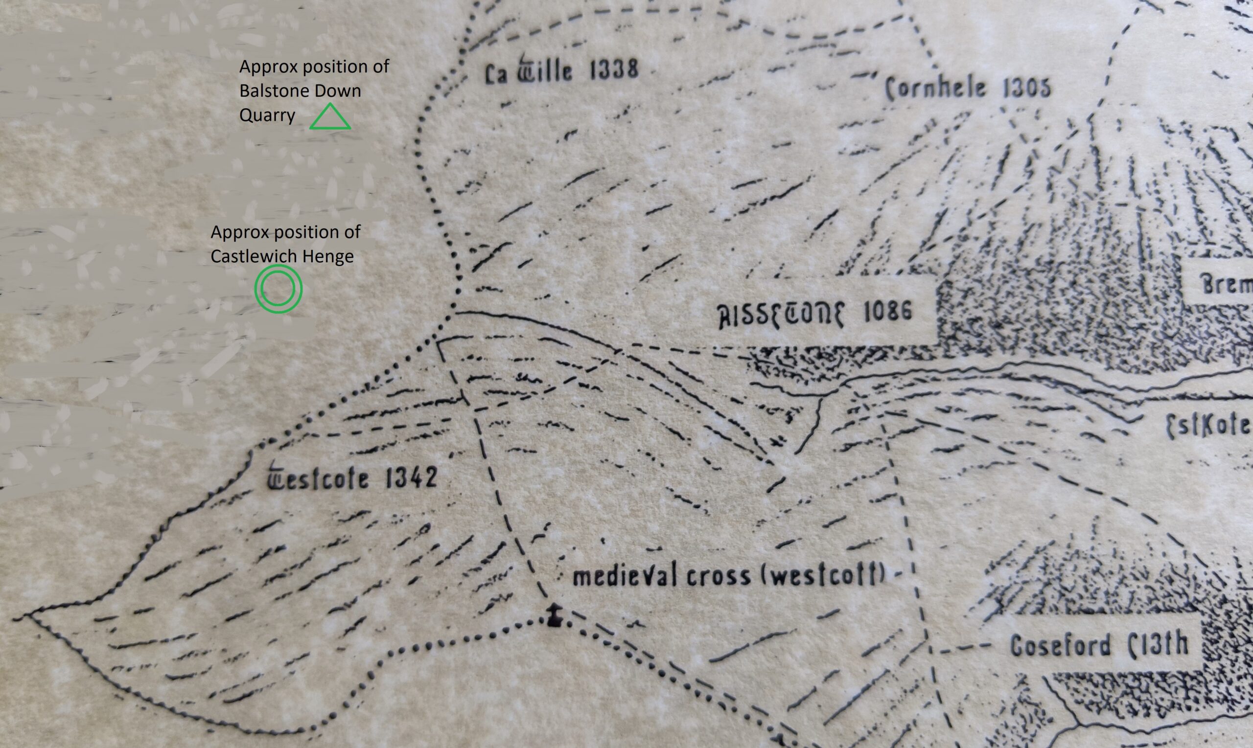
Setting this area in its larger pre-historic setting, by pulling our focus out a just a little, we find the Neolithic Henge (around 2500 BC) known as Castlewich Henge, situated between Castlewich and Westcott, and identified in 1951. This is not a henge like Stonehenge, but circular a bank and ditch henge, the ditch being inside the bank, of some 90m external diameter, and showing no signs of occupation (no signs of buildings within at anytime) and is therefore most probably associated with ritual or trade use in Neolithic times.

Above this, on the other side of the A388, is Balstone Down Quarry (in the triangle of trees between the A388 and the smaller road that cuts though to Callington) which was the site of Neolithic excavation and manufacture of greenstone axes – considered a Neolithic ‘axe-factory’.

Greenstone axes were prized in Neolithic times, a fine-grained dense stone it polished well and held an edge – and, for some reason, green-coloured hard stone, of any mineral composition, was popular across the Neolithic world. Some were for use but some are believed to have been used as ceremonial axes; given as gifts or deposited as votive offerings. Fifty-six greenstone axes, found in various places across the southern half of Britain, have been identified (by mineral analysis) as having come from ‘the Callington area’ and so most probably from the Balstone Down Quarry. There are only five greenstone quarries known of in Cornwall, only this one is near Callington and all the others further west – and producing a different quality of greenstone. (1)

That greenstone axes from this area were traded, and therefore found distributed across the country, bolsters the opinion that the henge may have been used as a site of trading, especially as a Neolithic ridgeway runs close to both these areas (quite likely part of the A388 follows this ridgeway)

A ridgeway was the Neolithic highway, going, literally, along the higher ridges where possible (safer to travel than the densely wooded valleys) from settlement to settlement. With the river offering a means of travel, this ridgeway is also believed to have headed down to the Tamar, quite possibly to the Halton Quay area, as travel by river was faster, safer and associated with trade. (2)

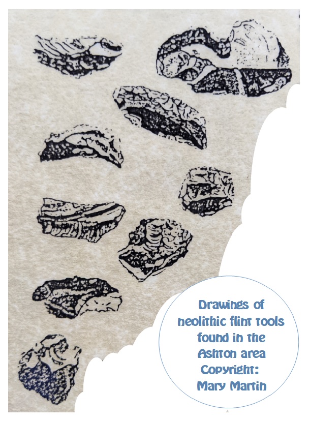
So, what of Neolithic evidence found within our ‘parish’ boundary, seeing as it is evidenced close by? Interestingly, the evidence within the parish is not of greenstone axes, but of a number of small flint tools discovered in the Ashton area. The picture below these is a drawing made by Mary Martin from the originals. (Copyright Mary Martin and reproduced here with permission) *when I have access to my stored papers I can replace this mono-chrome version with the original colour version.

I am not surprised that these were found in the vicinity of Ashton – as this is an area particularly well-endowed with springs – a pre-requisite for any early settlements. It is also closer to the recognised Neolithic features described above – henge, quarry (axe-factory) and ridgeway, – than the bulk of our parish area.

# Stepping out of the Neolithic: There are at least six springs in the Ashton area. Five of these had been turned into ‘captured-spring wells’* at sometime in history and given a little ‘well house’ – unfortunately there’s no date-line for this – but medieval is suggested (Noted by the Cornwall Archaeology Unit – referring specifically to Cornish Holy Wells “The numerous holy wells in Cornwall may be a reflection of a prehistoric, pagan, reverence towards water spirits and other natural forces. Many natural springs were provided with a well house or covering during the mediæval and later periods.” (3). The CAU only seem to consider ‘holy wells’ but there are many, many more ‘domestic captured spring wells’ that are totally disregarded and just disappear through lack of recognition or care)

*This is where a spring is dug out, a slate open box made, or carved rock basin placed, to contain the water and a little stone ‘well house’ made over it (back, sides and a roof, sometimes with a little slate shelf and usually a door to keep out animals and detritus). Water could then be dipped from this well, the excess water running over and out, making a small stream.

Four of these were visible roadside in Ashton until quite recently (when the falling of a hedgerow tree destroyed what was left of the little well-house of one and the other, basically one wall and a roof, just subsided into the stream), one is in the grounds of a cottage, one is semi-filled-in and hidden by undergrowth. The best condition and most visible is that beside Ashton Barton (the ‘manor house’ for the later Manor of Ashton) Photo below – if you zoom in you can see the well-water in the ‘box’.

REFERENCES

(1) https://link.springer.com/article/10.1007/s10816-019-09438-6Schauer, P., Bevan, A., Shennan, S. et al. British Neolithic Axehead D(2) Movement and mobility in the Neolithic. Editors: Jim Leary and Thomas Kadoristributions and Their Implications. J Archaeology Method Theory 27,

(2) Movement and mobility in the Neolithic. Editors: Jim Leary and Thomas Kador Click for link

(3) Cornwall Archaeology Unit – Holy Well
LINK cornwall-and-scilly-historic-environment-record/access-to-monuments/find-by-period/find-monuments-by-period/mediaeval/holy-well

Did you ‘Beat the Bounds’ back in the day? Do tell your tale in the comments!

Did you already know of Castlewich Henge and the greenstone axe ‘factory’ at Balstone Down?

Had you noticed the well-houses in Ashton – and in many other parts of St. Dominick too? 
Have you got one in your grounds, or in the lane outside locally?

Do SHARE and COMMENT – I love to hear from you. Xx Ann 🙂 

ps If you are reading this on email and would like to comment just click onto the title and it will take you to the actual blog – so you can comment there.
If it is the first time you have written a comment don’t worry if it doesn’t appear immediately, your first comment has to be verified (to keep the spam-bots out) and I do this personally – so I am sure to see your comment – thanks for reading – Ann
While you’re here PLEASE SIGN UP to this blog if you’d like to hear more – the box is at the top of the post on the right – Let’s keep in touch! I do not post often, perhaps fortnightly, so posts are easy to miss.
{I had been building my followers since 2011 – and had around 640 when an unfortunate technical issue meant that I lost ALL of these followers contacts – and need to start again
– so please do join to keep in touch}

Remember – reviews of books are a great way to say ‘thank you’ to an author if you like what they write,
  Thank You

History of St. Dominick – Introduction

Updated 2026

Back in 2021 our local Pub, the Who’d Have Thought It, St. Dominick, had the great idea of providing a BLOG for the parish (the village and the parish have the same name!) They then asked for contributors – and yours truly offered to write up an occasional series on the History of St. Dominick – as I have gathered a huge amount of information over the years.

Though aware that my blog is read all over the world {NOTE 2026 – I have now lost ALL these readers from all over the world due to a technical hitch – you may sign up at the top of the site – over on the right} I have decided to re-post these blog-posts here too. St. Dominick is ‘home’ and St. Dominica (the patron saint of the church – and therefore namesake of the parish) is my inspiration for the book I am researching and writing at the moment.

So – welcome to our little corner of Cornwall, and I hope you enjoy this diversion into its history.

When we moved into Radland in 1983 I was determined to find out the history of that old house – and that also led me into glimpses of the history of St. Dominick itself. However, it was the inspiration of The Parish Map Project (a Common Ground initiative) that led me to work with about forty people within the parish, with many doing the research, artists creating the illustrations and others providing services, like photocopying, all to create a series of maps illustrating the history of the parish.

part of the 1485 – 1748 map

If you were not involved, a little about the Project. Parish Maps could be of any material, design, interest-focus or scope. We decided to take five snap-shots-in-time – and base most of them on existing maps. Many households in the parish have a copy, and there is a large-size set hanging in the Parish Hall.

As there were no actual maps of the area until the sixteen hundreds, so the first map was dated at 1485 – showing everything we found from pre-history to that time. This date was chosen as it is also the start of the Tudor period. It is acknowledged that the relative stability of the Tudor period accelerated change in all parts of the country, making this point a good place to pause and look back.

The second map was dated 1748, and was based on an existing map you can view if you go to St. Michael’s Mount – drawn by Thomas Martyn. (Note 2026: there used to be a copy at Lanhydrock, but it is now not available to view) To this was added the research that was gathered that focussed on properties that had been built and were still there between 1485 and the map’s date.

part of 1748 – 1841 map

The third map is based on the Tithe Map 1841, probably the most detailed map made of the area – ever! A tithe map was made to commute tithes-in-kind (for example: one stook of wheat in every10 harvested) into a monetary value – so they could be paid that way instead. The original tithe map is huge – and barely any of the fine detail could be shown on our maps, but the basic information and everything discovered was added to the original map.

The fourth map was based on the 1951 ordnance survey map – and shows how life had changed dramatically over the previous 110 years – and brings us firmly into history as remembered by people born in St. Dominick.

The final map was set at the year we completed the project,1995, and yet, even in this short time-period since then the changes are dramatic to see in terms of housing development and change of use for other buildings.

In this occasional series I hope to share with you the research and the sources (where possible) and describe this area as it developed from just an area bordered by streams and the river, into the parish we know today. I do hope you’ll join me for the journey – Ann

Do you like local history?

What aspects interest you most?

Have you taken part in any history projects where you live?

love to hear from you 🙂 Xx Ann

ps If you are reading this on email and would like to comment just click onto the title and it will take you to the actual blog – so you can comment there.
If it is the first time you have written a comment don’t worry if it doesn’t appear immediately, your first comment has to be verified (to keep the spam-bots out) and I do this personally – so I am sure to see your comment – thanks for reading – Ann

Remember – reviews of books are a great way to say ‘thank you’ to an author if you like what they write,
  Thank You

One morning the sky seemed full of aircraft …

At last, the second volume of my father’s memoirs is published – and these are the first words of the first chapter, it is D. Day – and six days later it was his 18th birthday and his call-up papers arrived.

Sadly this is also the final volume of Frank’s memoirs – even though, if Frank had the time left to him to write them, he would have probably been into volumes 4 or 5 at the very least before the end.

Volume 2 takes him up until he is 28, he then began Volume 3 … but the rest of his life is sketched in by his children (myself and my brother Mark) covering almost all the interests he participated in over the years and explaining a few of those unexplained bits he put in his own writing – saying – ‘more about this later’.

Frank had always intended his memoir to be a record for his descendants though, with his eye for detail, it is also a great exercise in observation of life in those times and a good social comment from the point of view of the ordinary man.
With his descendants in mind, the book concludes with a piece he wrote before he began his memoirs – things he’d been told by his parents about their life and about their parents – taking the family memories back another generation.

The first four years of Volume 2 see him in the Army at the end of WWII and up until his (late) de-mob. In his inimitable ‘voice’ we have an insight into the induction of civilians into the war-time army and the procedures of life in the army.
Much of his time he was posted in Europe – and these chapters include his own photographs of places he saw (some from tiny pictures – about 1″ x 2″).

Talking of photographs, from after the war there is a picture of the first car he and his brother Peter got – the photo this was taken from was about a half inch square (12mm square).

Editing this was a mammoth task – and I am pleased that it has been achieved. For those of you who read and enjoyed his first volume – it is available via Amazon HERE. (Or directly from me if you live close enough to pick it up)
And for everyone – here is a sample of the rest of that first chapter.

Chapter 1 – Into the Army

One morning the sky seemed to be full of aircraft all with three broad white bands around their wings and fuselage. It was D day, 6th June 1944 and on the 12th of June I was 18 and I received my call up. With this came a travel warrant to report to Norwich barracks on the 29th of June. I had already handed my rifle into the Home guard but kept my uniform (battledress) to travel in – as I still had no decent civilian clothes.

On the afternoon before I went I pointed to the apples on the tree outside the window and said ‘There won’t be any of those left when I get home again.’

Next morning I set out to walk to South Zeal to catch the early bus to Exeter and the train to Norwich, a long tedious trip. When the train finally arrived we were met by Sergeants directing the recruits to army lorries. It seemed that all those that came from the West Country were pointed to a different lorry from the others. When we arrived at the barracks we were sent to the dining hall and given a mug of tea and a plate with something like soggy lumpy mashed potatoes – boiled butter beans – all ice cold. I started eating mine but sitting opposite me were two lads dressed in nice casual clothes moaning about the food, and when one reached across towards my plate and saying. ‘I don’t know how you can eat that,’ without thinking I slammed my fork into the table close to his hand and growled. He jumped back and said. ‘Christ where did they get you from?’ I was a bit disturbed as I realised I’d had a flashback to cripple school meals, and having to defend them.

The sergeant bawled out, ‘Outside for induction!’ I joined the induction queue and suddenly found myself in front of an ATS who snapped out, ‘Name?’ and then wanted all my other details, all in a tone that said I was holding up the complete war effort. Then she rattled off a string of numbers. I hesitated and she said, ‘That’s your number, move on.’ And then the confusion really kicked in as a single battledress was pushed towards me and the soldier behind the counter shouted out, ‘Battledress. two.’ (where others were given two) I realised that was because I was already wearing one.
As I progressed along the counter more clothes and equipment were pushed at me, each time with the description called out including a ‘housewife, soldiers for the use of’ which turned out to be a sewing and darning kit.
Then all the webbing equipment and water bottle were added, and just when I was so loaded I could not see over the top I got 3 blankets.
Again I was asked my number. I staggered away hoping I had got it right.

We were told we were now fully responsible for the kits and any loss or damage would be replaced at our cost. Then we were marched away to the barracks – which turned out to be the old cavalry section and the area I was in, with 30 others, was the ex stables and faintly smelt like it. I was given a bunk which happened to be double and the other lad opted for the lower one – I was pleased with that. Then the order came to change into uniform. I began to look round at the others and was surprised at the obvious difference in ages. I thought they would all be my age but the call up was gradually creeping up and among us were men who had been in the occupation army in Germany after the First World War. So what it amounted to was, of the thirty in the barracks room, some knew the routine of army life but the majority were all ages called up as their reserve jobs came to an end, but all mature and confident … and me. Confused, lost and, in modern parlance, definitely out of my comfort zone.

Finally – I would like to wish
YOU ALL a Very Happy and Hopeful NEW YEAR. May 2021 be a better and happier year for everyone, for you and for those you love.

I love to hear your comments – please do feel free to chat 🙂
X ANN

ps If you are reading this on email and would like to comment just click onto the title and it will take you to the actual blog – so you can comment there
If it is the first time you have written a comment don’t worry if it doesn’t appear immediately, your first comment has to be verified (to keep the spam-bots out) and I do this personally – so I am sure to see your comment – thanks for reading – Ann
Remember – reviews of books are a great way to say ‘thank you’ to an author if you like what they write,
  Thank You

Digging up the Past

Have you ever watched Time-team and thought ‘I’d like a go at that!’

Last year the Liskeard Poetry Group were invited – as poets – to attend an archaeological dig near St. Neot – with a view to writing poetry inspired by what we saw. So a few of us, mostly at different times and on different days, headed down the narrow (and very narrow) lanes to the site. I wrote three poems inspired by this event and which, with the poems from others, were published in a booklet.

It was expected that they would be digging in a bronze-age enclosure – as acquired archaeological wisdom said that by the iron-age these sites, on the high moorland, were abandoned.
By the time I attended – they knew they were working on what was an iron-age site.
None of this is important to today’s blog – except to say Archaeology is always turning up evidence that turns the ‘perceived’ way of the history around.
AND – whilst observing and drinking in the atmosphere – I thought ‘I’d like to do this!’

So, when I noticed that the dig at the nearby Calstock Roman fort was inviting community support in the terms of people prepared to spend anything from a week to four weeks, sitting on the ground and carefully scraping it away to reveal … whatever there was to be found.
I signed up for a week! And was accepted!

A little about this dig – to set the scene.

Twelve years ago no-one knew there was a Roman Fort in Calstock. The archaeological team from Exeter University were working on information relating to the medieval silver mines on the opposite bank of the Tamar at Bere Ferrers, when they went looking up on this hill, near the Parish Church, for the smelting works and the administrative buildings recorded in documents from the late thirteenth century. They did a geophysical survey in pasture below the churchyard – and were amazed to find a large Roman Fort!
Until then the Roman presence in Cornwall was thought to consist only of two forts one at Restomel on the Fowey and the other at Nanstallon on the Camel – guarding important river crossing points on both rivers. Both of these – though almost opposite each other on the narrower part of the peninsula – are a long, long way from Calstock, Which is just on the Cornwall side of the River Tamar … about at its highest navigable point – and a possible crossing point.

I loved the description of what you needed to bring/wear/ for the dig. Wet weather coat / trousers / stout boots / sun hat / sun-lotion  – lunch and a chair. i.e. Be equipped for anything the British summer can throw at you! Oh! And make sure you are up-to-date on your tetanus injections!

Day one – Monday: The forecast as recently as a week ago had been for a dry week. Monday dawned damp and threatening rain. I was glad had dug out two sets of wet-weather coats and trousers (one set as a back-up pair) hiking boots and water-proof gardening gloves over the weekend. 

The gaggle of newbies was introduced to the archaeologists working there – so we knew who was who, and who were other amateurs. Already the volunteers who were working more than one week were out on the ground, looking very professional and at home.

We were then given an overview of what this dig was trying to accomplish – and in this case, it was to gather all and any information from this section of land that was just outside the West wall of the Roman fort – and that was due to become the extension to the Calstock churchyard which it abutted on to.

The whole site had had the general swathe of top-soil removed and heaped around the edges. However, there was still some to remove until the, potentially, Roman remains would be found.

Quite quickly we were set in a line to begin clearing back down to the ‘grey’ – to the change in soil colour, in one un-worked corner of the site.

Our tools: Bucket, kneeling mat, small trowel, brush and shovel – and lots of elbow grease. It was my theory that we were to to work on shifting lots of ‘unimportant’ soil so that by the time we were given something else to work on, that might matter, our arms would be aching and we’d go slower  😉 (the kneeling mat supplied was the green one in this picture – I’d also brought the gardening one with ‘arms’ with me. Very useful for getting up off of your knees again!)

A hole of our own to dig in.

However – before we knew it, we were each given an area to dig ourselves. Though most of these were not thought to be something that might bear a lot of interest, as they though most were in a line of a ditch and bank created to border a field at some time, and then left to collapse or pushed down and ploughed over.

The first step was marked out by the archaeologists – who also marked it on a plan and gave it a number. We were then told to work our way down in layers, removing the infill – scraping, checking, putting the spoil in buckets and tipping the spoil way up on the heaps at the sides.

Lunchtime came, pleasant chatter in the tent-like shelter – then back to work … the dark clouds gathered … and from a few heavy drops as warning … we were soon running for shelter from a torrential downpour.

Huddling under the shelter we waited – with the archaeologists nipping out to assess the situation whenever it eased little bit

Eventually they said – that as all the holes were full of water – we’d have to call it a day and resume tomorrow. [photo shows post holes, excavated the previous week – water logged]

Tuesday.  Straight back into the work. I was amazed how much the ground had absorbed and dried up. The soil in the infill, however, was now sticky and would not brush. The whole morning went by, scraping, always watching every scrape, pushing the earth onto the shovel with the trowel, watching as it went, then last glance as I was tipping it into the bucket – repeat … empty the bucket… repeat all.

[photo shows various sections taken out along the line of the ditch and bank]
By the end of the day my knees knew what I’d been up to. As did my back. But I had essentially finished, the hole was scraped down to the dug-out bedrock from side to side, and vertically at each end of my section. Photographs were taken… and it was time to pack up for the day.

Wednesday. I was introduced to how to draw and measure the section that had been taken out.

The line was place taut and straight with the top of the soil. On this was hung a level, and the nails holding the line adjusted until it showed it was level.

Then came ‘the taking of the measurement above sea-level’. This was done using a theodolite which had already been zeroed on a peg set in at the edge of the site. With one person supporting the measuring pole, keeping it vertical by means of a bubble in a ring-sight – and the other sighting on it using the binocular sights – and within those the centre cross of three – the number was read off. Once it had been assured the theodolite had not been moved since it was set up – the person carrying the measuring pole moved to ‘balance’ the pole on the string line above the soil at the site of the hole. Readings taken – and some mathematical jiggery-pokery – and they could pinpoint the height above sea level of the top of my section of the digging. From this line I then had to write down the measurements to the top of the soil – at 10 cm distances. Then repeat the exercise – this time measuring the bottom of the hole at each point – or sometimes more frequently, if the line was a steep decline or incline.

This made a profile of the face of the infill. If there had been stones, or anything of note (except roots) these would have been sketched in.

The whole process was then repeated for the other side of the section cut. All these were cross-referenced by the section number and the sheet numbers and anything else that would mean they could link together photographs, drawings, and the plans.

This took almost all day!

Shortly before the end of the day, however, I was sent to help on a different part of the site – where a similar trench was being cleaned out – there I joined two other volunteers, one very experienced, the other, a newbie, like me – until the end of the day.

Thursday.

The other newbie, Judy, and I started on the same section in the morning, but we soon reached a point where we went off to find an archaeologist to tell us what to do – as it was obvious that the section we were working on was about to join a different feature coming in from the side.

We were then set to create a ‘relationship trench’ which would show any relationship between the two, or three, features. A ‘feature’ just meant something that showed as darker earth in the grey-slatey natural soil.

There was the original trench we were working on – which looked like it continued past these other features. Then there was a narrow, slightly curved, shallow trench coming in at almost right-angles from the side and, just before it met our wider trench, a just over semi-circular patch abutting it which they called ‘the pit’ though it was only about the size of a tea-plate. We were to cut half-way through this, across the narrow trench to the mid-point, then take a sharp right-angle and go down the length of the narrow trench and right across the full width of the wide trench.

The archaeologist scraped back the surface to see the edges of the feature before putting in the nails and strings – stopped – picked up a piece of black stone the size of my little finger-nail, rubbed it – and said – ‘Hmm, worked flint!’ And it was, a micro-lith – tiny knapped edge and all! Well, that was guaranteed to make sure we looked carefully at every scraping!

The rest of the day Judy and I worked on these sections, and left it hoping it wouldn’t rain too much and fill our work with mud – as it was in the lower part of the site.

Friday.

I couldn’t believe it was Friday already. If I hadn’t already been booked up with lots of other jobs to get done I would have gladly worked on – and apparently – I would have been welcome to do so – even though not booked in. Note this for next year!

Our relationship trench was in fairly good order in the morning – in fact it was harder to work as the ground had dried out – but easier to brush – as it wasn’t so claggy.

All the Photographs had to be taken, and listed in the book – the direction, the faces, the section numbers. An Archaeology student came and fixed the lines straight and level – as in photo above. Then the measurements, above sea –level and from the lines had to be done. Though this went quicker with two of us doing it. The drawing was slightly different as we had to show what was actually two faces at right angles to each other – in one continuous line – with a dotted line and a symbol to show where it took a right-hand turn. (drawing below)

The quality and colour of the soil in the ‘pit’ was different from the narrow trench it abutted. The narrow trench did not quite break through into the wider trench – there being a small rise as a lip between them.

There was a very narrow darker line travelling diagonally across the area ending at the tiny ‘pit’. I longed to investigate it … but our time was almost at an end.

I looked round the site at what else was being found and what else was going on. Big questions about the unusual diggings near the Roman road into the West gate of the fort were in the air … exciting possibilities … and the possibility of finding out more as the top edge of yet another one was found in an extension to the original dig site area.

Lovely bits of pottery, Samian ware – with evidence of repair, native black-ware, jug handles, bits of amphorae … two whet stones – one probably Roman from one pit – the other iron-age from a different pit.

Photo above shows items from a waste pit – including 3 pieces of samian ware.
You can see other pictures and information on their FB page  https://www.facebook.com/UnderstandingLandscapes/

Was it a good experience – Yes

Would I do it again – Yes!

Looking forward to seeing how much time I can be free for when they announce the 2020 dig now!

Have you ever joined an archaeological dig?

Did watching Time-Team make you want to join one?

Do share – you know I love to hear from you 🙂

ps If you are reading this on email and would like to comment just click onto the title and it will take you to the actual blog – so you can comment there
If it is the first time you have written a comment don’t worry if it doesn’t appear immediately, your first comment has to be verified (to keep the spam-bots out) and I do this personally – so I am sure to see your comment – thanks for reading – Ann

Remember – reviews of books are a great way to say ‘thank you’ to an author if you like what they write,
  Thank You


No so much Navel Gazing as …

Oh! Here I am, back again after what seems a frenetic and frantic time. Oh, yes, life sometimes throws things our way that knocks all the writing to pot – including the blog.

In this case my father’s sudden eruption of a HUGE ulcer on his tongue, followed by numerous and sequential trips to the hospital for every type of scan, followed swiftly by an operation to remove a largish bite of his tongue and several lymph nodes from his neck following the diagnosis of cancer. Thank goodness for the NHS! Subsequently we’ve been on the recovery stage – trying to regain weight lost while eating was difficult – while eating is still difficult (with sore but healing new shaped tongue) However, things are stabilised now and I have found my lap-top and returned to all of you.wp_20170512_09_02_15_pro

And returned to the studies of everyday plants that my character – Dominica – might be able to use in her healing around AD689 – and today I’m looking at the plant known as the navelwort – or pennywort.

Wort, or wyrt,  is actually a Viking or Norse suffix meaning ‘medicine’. So the name of this plant in this country comes from later than the time I am dealing with, so I have to check with my sources as to whether it was an introduced plant – or was here already but known by another name. (Yes, Historical writing is tricky!)

I have always rather liked this plant. The round fleshy leaves are one of those edible leaves that my boys readily took to eating just for fun (after being told they were edible) They taste a bit cucumbery.. basically fleshy, wet and green, not bad in a sandwich. However, I didn’t know of their medical usage. The names, pennywort and navelwort I assumed came from their shape and the dimple, like a bellybutton, in the middle, even though, somewhere in the recesses of my mind the ‘wort’ rang a herbal-use bell.

wp_20170623_10_52_15_proNow, the mini-course I went on tells me that the navelwort, Umbilicus rupestris, have strong antimicrobial properties and would have been placed over the end of the umbilical cord and tied on, where they would dry-on forming a seal and keep infection at bay. Thus navelwort referred to this property (though under the doctrine of signatures – they would also have been saying – ‘look at me, I’m for use on the navel!’) Oddly, this use doesn’t seem to be generally mentioned in online sources, so maybe it’s a very old use, perfect for my story.

It seems that these can also be carefully dried and stored for babies that arrived out of the navelwort-growing season too. Now I am really hoping this plant in a real native as I am sure this could work its way naturally into Dominica’s medicine kit.

So, barring any other type of emergency, medical or otherwise, I’ll write to you next week – in the meantime –

have you ever eaten a pennywort sandwich – or even just nibbled a leaf?

Or do you know these plants by any other names?

Do share – you know I love to hear from you!

A Weedy Medicine Cabinet – Dandelions

Here we are again, we are back in the late AD600 – when the wise-woman, or the monastery-trained, were the go-to people when you were ailing. Why? Mainly because they still held the knowledge honed by the druids about which herbs had which effects on the body.

So it is that I found myself signing up to a herbalist-led course here in the Tamar Valley. My Dominica will have to use the plants that grow here if she is to be a healer (which – in my telling of the tale – she will be)

Here I am going to give a first glimpse of what I learned but how this will be used in the story I have yet to discover (that’s the way my writing works – fill up the  brain with lots of information and then let the sub-conscious sift through and weave it’s own patterns).

We didn’t even have to leave the property where the talk took place – and I suspect you wouldn’t have to stray far from your garden too for the one herb I’m going to touch on here. wp_20170512_09_06_03_pro

Hands-up those who have dandelions in their garden? *sees a forest of hands* Really? LOL 🙂 … well it seems that a Dandelion is a medicine chest all on its own.

Leaves: Make a ‘tea’ from them to drink. (A ‘tea’ basically is as it sounds, pour boiling water over them and allow to steep for a few minutes – remove herb bits – drink)

Many of you will know this is a diuretic (we all remember the warning as children not to pick dandelions as they will make you wet the bed!) Diuretics are used in many conditions today: – for reducing blood-pressure; congestive heart-failure and oedema (swelling due to water-retention) *This is not to say you should treat yourself for these conditions willy-nilly with dandelion tea!*

But did you know that dandelion tea is also a anti-lithic (a stone-breaker) that breaks gall or kidney stones to allow them to be passed?

Roots: Wash, cut and make a tea – this provides a liver-detox.

Then there’s the sap – that white milky fluid that comes from the broken stem. This can be used to treat warts. It is actually a form of latex and seals the wart off from the air. It needs to be reapplied frequently but eventually the wart will drop off leaving a wet pit on the skin that then heals up. (this make total sense – if you recall my experiment with the duct-tape method of wart removal (here) this works in the same way)

dandelion-fiels-freeimages-live! Not only that – but apparently dandelion sap was even used during the war as a latex (rubber) supply (Not one of us on the course had ever heard of that before!) but as things go – in a serendipitous manner – within a day an advert popped up on FB for Continental tyres – saying they are experimenting with dandelion rubber (due the disease attacking rubber plants worldwide) as well as for other things that use latex.

That’s dandelions for you – amazing and fascinating – now I need to check with Dulcie of Dumnonika, the Iron Age re-enactment group, who has an careful list of truly native plants, whether they were here in this part of the UK back in those times.

I’ll share some of the other medicinal-weeds I learnt about with you another time  🙂

What are your favourite herbal remedies?

Do you remember the warnings about picking Dandelions?

Do Share – you know I love to hear from you!

Lost in Time – researching for Dominica!

I’ve been gone one thousand, three hundred and twenty-eight years – back in time … to an era we call ‘The Dark Ages’. The Roman garrisons have gone – left these isles to tend to their problems closer to Rome with a farewell letter to the Romano-British from the Emperor Honorius, in AD410, to see to their own protection  – even as they called for aid to fend off the raiding Saxons. However, by the date I’ve been visiting, AD689, the Angles, Jutes and Saxons are well ensconced in the majority of what will become England, but the Vikings are not yet attacking.

wp_20170406_15_34_30_pro
Can you see the river Tamar, just behind the trees – and further beyond?

I am in Cornwall, here, just over the border – the river Tamar. Though, in AD689 Cornwall is not Cornwall – as such, it is part of Dumnonia, roughly Devon and Cornwall and part of Somerset and Dorset, and it is a different place culturally to the rest of ‘England’. The West Saxons (those being the closest – Wessex) have not overtaken the people of Dumnonia yet – in fact – even the Romans had made little impact here, this side of the river, either … a few forts only – no fancy towns all laid out Roman style with villas and influence over the local Kings* here. (*or ‘big-man’ as the system seemed to be in Cornwall in the pre-Roman times … and probably was even at the end of the AD600s.)

So it is a tumultuous time on the border, the threat of invasion by the West Saxons is real, they have made in-roads into Dumnonia … and they have a new battle-cry. By this time the Anglo-Saxons had, by and large, turned from their pagan gods to Christianity, some converted by missionaries from Rome, some by missionaries from Ireland. This had resulted in a clash of Christian doctrines – the Roman church and the Celtic church having different ways to work out the Christian calendar, different tonsures for their monks, and differing rules and ways of worship and a different attitude towards women. Within my time-line comes the decisive synod of Whitby, AD664, that found in favour of the Roman Church and meant that the Celtic churches that would not change were then seen as heretical – and to be wiped out.

The Church in Dumnonia, and especially the ‘Cornish’ ones backed by King Geraint and so rich in Celtic saints from Ireland, refused to change – setting themselves up for the West Saxons to proclaim a ‘religious war’ as a motive to back-up their invasions.

It’s been hard to get back to the here and now – I look at the landscape around me with different eyes – where would have been occupied? Where would have been safe? I read the names of the places I know and refer to my books to see whether I can call the place by its current name – whether the name we know is, in fact, original Celtic (Cornish) or an English name given only after the West Saxons’ invasion, or a blend … and even that has made me look at the landscape again and see things with different eyes as I find the meanings behind the words.

Those who know me in person, know that I am interested in history, mainly local history rather than that of Kings and Queens, but this is something different. To weave a story based on a few scanty legends (Dominica and Indract), set in a time that is poorly recorded (there’s the reason it is called the Dark Ages) and to try to throw myself back into that time and inhabit that landscape and that life is, for me, an extraordinary experience, both thrilling and very scary. It is also totally absorbing and takes me to a place I have never travelled before!

Wish me luck on my time-travels 🙂

Do you go time-travelling?

Do you find yourself inhabiting a different world when visiting ancient houses or estates?

Do share – you know I love to hear from you!

The Way We Were …

I was told to clear out the old bureau – the idea being that we are de-cluttering – bit by bit.

Hmm… Result – a huge bag of old (and very old) bills, bank statements, leaflets, birthday cards (saved for ??), random sheets of paper with notes on, magazine and newspaper cuttings (now no longer relevant), posters (now tatty round the edges) to go to recycling or shredding and composting.

Plus, many, many things, that I want to keep, that I don’t know what to do with, or where else to keep them, including a drawer full of photographs. At the bottom of the draw, almost lining the whole of the drawer, just where they had been placed about thirty-three years ago when we moved here, were two photographs in a long-sleeve. I knew what they were immediately. …. End of college photographs.

wp_20160928_14_26_25_pro

At Shoreditch Teacher Training College (actually situated in Surrey, at Englefield Green, over looking Runnymede on the Thames)shoreditch as in many other institutions I expect, when the year group reached the end of their course a whole group photograph was taken … then, while the staging was all up and the photographer waited, we all ran off and came back ‘dressed-up’.

Look at this one – it should have been entitled ‘would you really want this lot teaching your kids?’ wp_20160928_14_25_49_pro

Can you spot me?  Here I am in both … close-up … now can you find me??

wp_20160928_14_26_46_prowp_20160928_14_26_02_pro


Two things occurred to me (we will all be in our sixties) – where are all these people now?

and

If this is done nowadays (and I have no idea if it is or not) you can bet that the ‘costumes’ would be more than ‘dresses’ using the curtains from the halls of residence, or bedsheets as nuns-habit, or ‘flasher-man’ lab coats, or ‘funny’ hats and cuddly toys .. as now everything is ‘professionalised’ not just thrown together with a bit of imagination and no cash. I can imagine the local hire-shop would be at the ready to provide ‘funny’ outfits for prospective teachers (or whatever), the internet peppered with good ideas and where to get them.

So, if you are in one of these photographs do let me know! I’d love to know where you are now and what is happening in your life.

If you have a similar set of pics from your past – do tell! What does it make you think about?

Do you keep lots of things that you don’t want to part with – but don’t know what to do with either?

Did you find me – just click on the photo to enlarge (and clarify) it – if that helps 😉

You know I love to hear from you … do share 🙂

error

Enjoyed this blog? Please share :)