History of St. Dominick – Map 1 {Pre-history – 1485} Part 2 – Bronze-Age times

{For previous posts on the history of this area see St. Dominick History tab under ‘History – local and everyday’ Topic}
Staying with our ‘pulled out’ focus we can see the only really local evidence of occupation in the Bronze Age (2500 – 800 BC). Up on Viverdon Down are a number of Bronze-Age bowl-barrows (burial mounds) Note: Barrow-burial is on a continuum from late Neolithic and through the Bronze-Age, and it has been noted in ref (3) that these would have also been visible from Balstone down. See map below

Cornwall Council Strategic Historic Environment Service in their article on Bronze-Age monuments in Cornwall states “Some mounds are probably burials of important people. The largest barrows are in prominent locations on hilltops and ridges. The smaller barrows, which do not normally survive in lowland Cornwall, are inconspicuously sited amongst the fields and near the contemporary settlements.” and “We can conclude that the many barrows found elsewhere in lowland Cornwall (eg. Cubert Common, Veryan Beacon) would have had round house settlements close by which are not now visible.” (1)

St. Dominick counts as ‘lowland Cornwall’. The earlier Bronze-age settlements were up on what we now term moorland – Roughtor, for instance, had a very large settlement, Bodmin Moor had many and their field systems can still be traced by low stone banks. The thought being that, as the soil in these areas became degraded by over use, they had to move onto the lower land, setting the pattern for farming today. Most lowland settlements, therefore, would have been created in the Middle Bronze Age (circa 1500-1200 BC) and were collections of circular houses.

However, their monuments (the burial mounds) were still usually situated on high-ground where possible, as Viverdon Down is.

Historic England records this listing: “Two bowl barrows on Viverdon Down, 540m north west of Tipwell Farm – This monument, which falls into two areas, includes two bowl barrows situated on the summit of a prominent hill called Viverdon Down which forms the watershed between tributaries to the Rivers Lynher and Tamar. The barrows survive as circular mounds surrounded by buried quarry ditches from which the construction material was derived. The eastern barrow mound measures 18m in diameter and up to 1.2m high, the western barrow mound is up to 14m in diameter and 0.9m high.” (2) (This is noted as a ‘legacy listing’)

sketch of the cross-section of a typical bowl-barrow

Though these barrows have not been investigated by excavation the construction of them has been observed by the Cornwall archaeology Society in 1994 when they visited. “Two barrows remain as prominent surface features, but erosion is being accelerated due to continued ploughing. The latter has nevertheless revealed the structure of the barrow mounds, with turf stacks capped with (now leached) orange clay presumably dug from encircling ditches.
This degraded capping forms a near-continuous ring around the larger, more northerly, barrow. Both within this ring and outside it, dark organic weathered blocks of turf indicate something of the former extent of the stack. Between the barrows, and slightly westwards, a further area of darker material in the plough-soil suggests the former existence of a third, smaller, barrow.” (3)

Follow the link under (4) in the References to help you try to locate these on the satellite view of the area with ‘side-by-side’ maps.

The question is, where is the settlement that sited these bowl-barrows on the hill? Now, what follows here is supposition – but the landscape around the hill is, even today, sparsely populated by any ‘homesteads’ – but just off the crown of the hill (and at the edge of St. Dominick parish) is ‘Tipwell’.
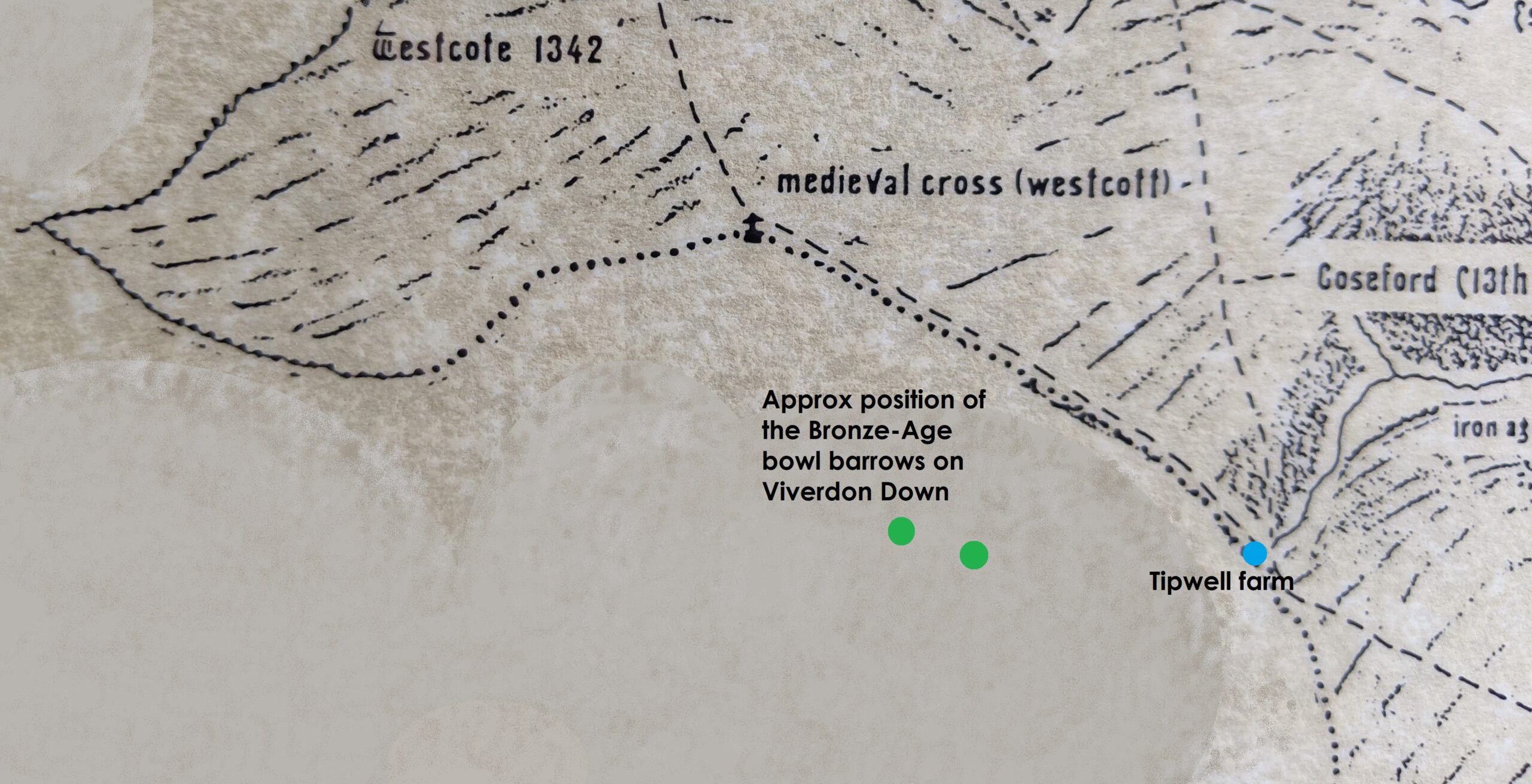
The name gives us the clue – most likely a settlement or homestead based on a well* – and it is indeed where another significant stream for St. Dominick starts. As we noted in the last part of this series – a water-source is an essential for a settlement.
*[The name Towell – further into the parish – for instance, comes from the name At-Well (or AtteWell as it was written in the Manorial records) – so maybe that this is the origin of the name Tipwell too?]

A settlement at Tipwell would also have had the advantage of being near to the route of the ridgeway – which would still have been in use at this time – and, if the hypothesis of the route also going down to the river is correct, it would be on that too – a well placed settlement.

However – as the Cornwall Council Strategic Historic Environment Service comments “the evidence of these lowland settlements have, largely, been completely ploughed away”(4) or, indeed, maybe the settlements themselves were just built over – so we may never be absolutely sure.

That is it for the Bronze-Age in our area – as nothing else has been found and recorded – unless you know different, if so, please let me know!

Did you know there were Bronze-Age barrows on Viverdon Down?

Do you have any comments on this History of St. Dominick so far?

We would love to hear from you 🙂

-Ann

References:

(1) & (4) Cornwall Council Strategic Historic Environment Service

https://www.cornwall.gov.uk/environment-and-planning/strategic-historic-environment-service/cornwall-and-scilly-historic-environment-record/access-to-monuments/find-by-period/bronze-age-2500-to-800-bc/

(2) https://historicengland.org.uk/listing/the-list/list-entry/1004394

(3) Cornish Archaeology No. 33 1994

Keith Ray: The barrow group at Viverdon Down, St Mellion: some observations on 24th April 1994

(4) Side-by-side maps to try to locate the barrows on satellite view (cursor and + sign show positions on corresponding maps)

https://maps.nls.uk/geo/explore/side-by-side/#zoom=17&lat=50.48467&lon=-4.28294&layers=193&right=BingHyb

Do SHARE and COMMENT – I love to hear from you. Xx Ann  

While you’re here PLEASE SIGN UP to this blog if you’d like to hear more – the box is at the top of the post on the right – Let’s keep in touch! I do not post often, perhaps fortnightly, so posts are easy to miss.
{I had been building my followers since 2011 – and had around 640 when an unfortunate technical issue meant that I lost ALL of these followers contacts – and need to start again
– so please do join to keep in touch}

ps If you are reading this on email and would like to comment just click onto the title and it will take you to the actual blog – so you can comment there.
If it is the first time you have written a comment don’t worry if it doesn’t appear immediately, your first comment has to be verified (to keep the spam-bots out) and I do this personally – so I am sure to see your comment – thanks for reading – Ann

Remember – reviews of books are a great way to say ‘thank you’ to an author if you like what they write,
  Thank You
History of St. Dominick – Map 1 {Pre-history – 1485} Part 1 – Neolithic times

{continuing the ‘occasional series’ For previous posts on the history of this area see St. Dominick History tab under ‘History – local and everyday’ Topic}}

The original of this project map was created by the late John Dyke, an artist and, during the second world war and before his retirement from the NT, a cartographer, who used to live in Bohetherick.

On this map he included the streams and the river and dotted in the tracks that we believed would have been there by 1485, as they went from farm to farm or from these to the Mills, Church or the Manor houses. This was then shaded to show the hills in the manner used on very old maps, so that hills appear in profile even though the map is in plan-view.

Section of Map 1 with added Neolithic detail outside parish boundary

However, in prehistory – of course – there was no such designated area as our Parish, but what there most probably was were the streams and the river. From countries, to counties to parishes, natural features, such as rivers and streams have been used to delineate borders, and so it is with St. Dominick parish – and it is that which gives it its shape and the slightly odd pointed end.

If you look at a reasonable large size ordnance survey of the area you will see that there are two main streams issuing into the Tamar, either side of our parish. One comes out beside Cotehele quay, the other at the far side of Halton Barton and Strawberry Hill, before Pentille. If you follow these up – you will see the parish boundary follows them as far as they go to at least one of the their higher sources (streams often having a few springs converging on them) From the highest point of each is a short run on up – and across what is now the A388 to join with the rising of two separate springs which themselves converge – and this is the odd pointed bit that just takes in Westcott. A rough sketch is shown below:

At one time it was a ‘fun’ and ‘educational’ event to ‘Beat the Bounds’ where ‘everyone’, especially the young* were taken around the whole parish boundary (*to teach them where the boundary lay). I understand there are many in the parish who took part in the last one held here – and have heard tales of this, especially concerning Westcott. Do comment if you have a tale to tell!

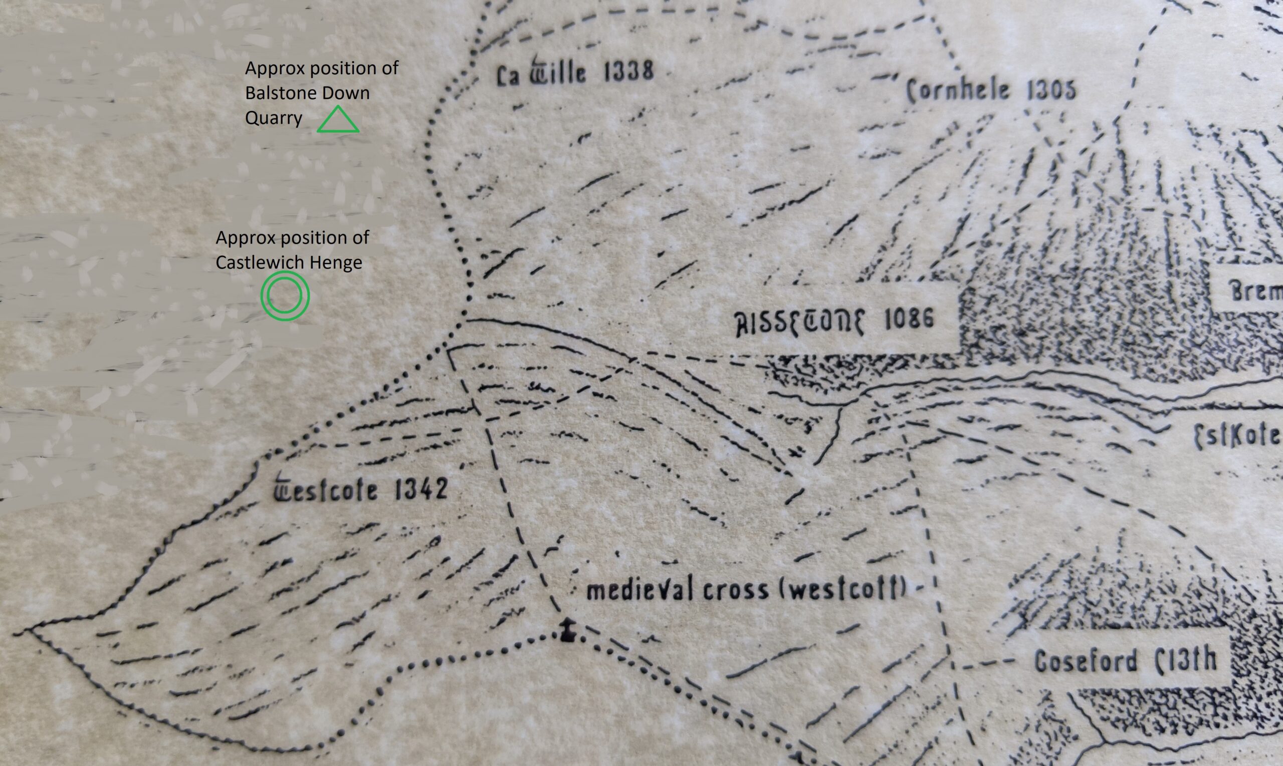
Setting this area in its larger pre-historic setting, by pulling our focus out a just a little, we find the Neolithic Henge (around 2500 BC) known as Castlewich Henge, situated between Castlewich and Westcott, and identified in 1951. This is not a henge like Stonehenge, but circular a bank and ditch henge, the ditch being inside the bank, of some 90m external diameter, and showing no signs of occupation (no signs of buildings within at anytime) and is therefore most probably associated with ritual or trade use in Neolithic times.

Above this, on the other side of the A388, is Balstone Down Quarry (in the triangle of trees between the A388 and the smaller road that cuts though to Callington) which was the site of Neolithic excavation and manufacture of greenstone axes – considered a Neolithic ‘axe-factory’.

Greenstone axes were prized in Neolithic times, a fine-grained dense stone it polished well and held an edge – and, for some reason, green-coloured hard stone, of any mineral composition, was popular across the Neolithic world. Some were for use but some are believed to have been used as ceremonial axes; given as gifts or deposited as votive offerings. Fifty-six greenstone axes, found in various places across the southern half of Britain, have been identified (by mineral analysis) as having come from ‘the Callington area’ and so most probably from the Balstone Down Quarry. There are only five greenstone quarries known of in Cornwall, only this one is near Callington and all the others further west – and producing a different quality of greenstone. (1)

That greenstone axes from this area were traded, and therefore found distributed across the country, bolsters the opinion that the henge may have been used as a site of trading, especially as a Neolithic ridgeway runs close to both these areas (quite likely part of the A388 follows this ridgeway)

A ridgeway was the Neolithic highway, going, literally, along the higher ridges where possible (safer to travel than the densely wooded valleys) from settlement to settlement. With the river offering a means of travel, this ridgeway is also believed to have headed down to the Tamar, quite possibly to the Halton Quay area, as travel by river was faster, safer and associated with trade. (2)

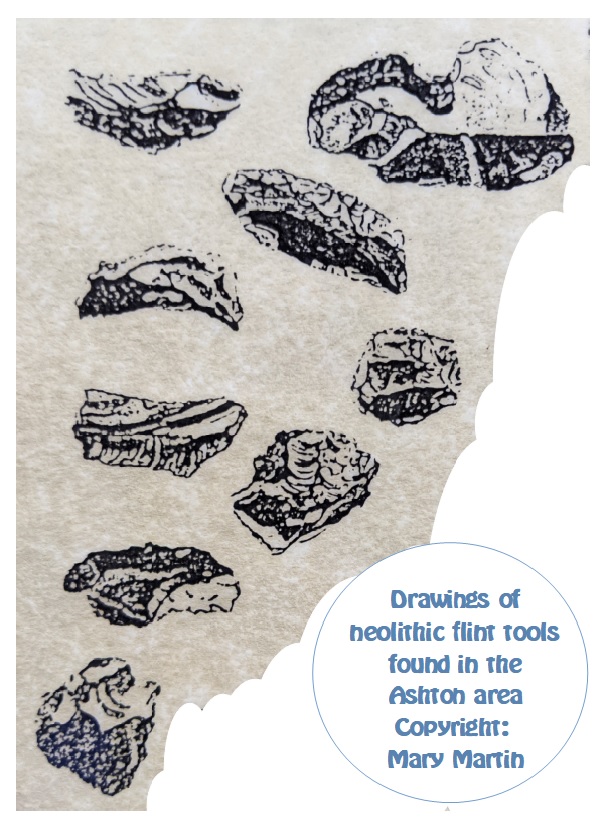
So, what of Neolithic evidence found within our ‘parish’ boundary, seeing as it is evidenced close by? Interestingly, the evidence within the parish is not of greenstone axes, but of a number of small flint tools discovered in the Ashton area. The picture below these is a drawing made by Mary Martin from the originals. (Copyright Mary Martin and reproduced here with permission) *when I have access to my stored papers I can replace this mono-chrome version with the original colour version.

I am not surprised that these were found in the vicinity of Ashton – as this is an area particularly well-endowed with springs – a pre-requisite for any early settlements. It is also closer to the recognised Neolithic features described above – henge, quarry (axe-factory) and ridgeway, – than the bulk of our parish area.

# Stepping out of the Neolithic: There are at least six springs in the Ashton area. Five of these had been turned into ‘captured-spring wells’* at sometime in history and given a little ‘well house’ – unfortunately there’s no date-line for this – but medieval is suggested (Noted by the Cornwall Archaeology Unit – referring specifically to Cornish Holy Wells “The numerous holy wells in Cornwall may be a reflection of a prehistoric, pagan, reverence towards water spirits and other natural forces. Many natural springs were provided with a well house or covering during the mediæval and later periods.” (3). The CAU only seem to consider ‘holy wells’ but there are many, many more ‘domestic captured spring wells’ that are totally disregarded and just disappear through lack of recognition or care)

*This is where a spring is dug out, a slate open box made, or carved rock basin placed, to contain the water and a little stone ‘well house’ made over it (back, sides and a roof, sometimes with a little slate shelf and usually a door to keep out animals and detritus). Water could then be dipped from this well, the excess water running over and out, making a small stream.

Four of these were visible roadside in Ashton until quite recently (when the falling of a hedgerow tree destroyed what was left of the little well-house of one and the other, basically one wall and a roof, just subsided into the stream), one is in the grounds of a cottage, one is semi-filled-in and hidden by undergrowth. The best condition and most visible is that beside Ashton Barton (the ‘manor house’ for the later Manor of Ashton) Photo below – if you zoom in you can see the well-water in the ‘box’.

REFERENCES

(1) https://link.springer.com/article/10.1007/s10816-019-09438-6Schauer, P., Bevan, A., Shennan, S. et al. British Neolithic Axehead D(2) Movement and mobility in the Neolithic. Editors: Jim Leary and Thomas Kadoristributions and Their Implications. J Archaeology Method Theory 27,

(2) Movement and mobility in the Neolithic. Editors: Jim Leary and Thomas Kador Click for link

(3) Cornwall Archaeology Unit – Holy Well
LINK cornwall-and-scilly-historic-environment-record/access-to-monuments/find-by-period/find-monuments-by-period/mediaeval/holy-well

Did you ‘Beat the Bounds’ back in the day? Do tell your tale in the comments!

Did you already know of Castlewich Henge and the greenstone axe ‘factory’ at Balstone Down?

Had you noticed the well-houses in Ashton – and in many other parts of St. Dominick too? 
Have you got one in your grounds, or in the lane outside locally?

Do SHARE and COMMENT – I love to hear from you. Xx Ann 🙂 

ps If you are reading this on email and would like to comment just click onto the title and it will take you to the actual blog – so you can comment there.
If it is the first time you have written a comment don’t worry if it doesn’t appear immediately, your first comment has to be verified (to keep the spam-bots out) and I do this personally – so I am sure to see your comment – thanks for reading – Ann

While you’re here PLEASE SIGN UP to this blog if you’d like to hear more – the box is at the top of the post on the right – Let’s keep in touch! I do not post often, perhaps fortnightly, so posts are easy to miss.
{I had been building my followers since 2011 – and had around 640 when an unfortunate technical issue meant that I lost ALL of these followers contacts – and need to start again
– so please do join to keep in touch}

Remember – reviews of books are a great way to say ‘thank you’ to an author if you like what they write,
  Thank You

error

Enjoyed this blog? Please share :)